G
La Garzette
Le journal le plus lu les pieds dans l'eau. Abonnez-vous !

The Loire flows through regions with highly varied soils, and carries their sediments all the way to the sea. The Loire Valley’s landmark monuments and castles could be built thanks to the mining of its limestone.
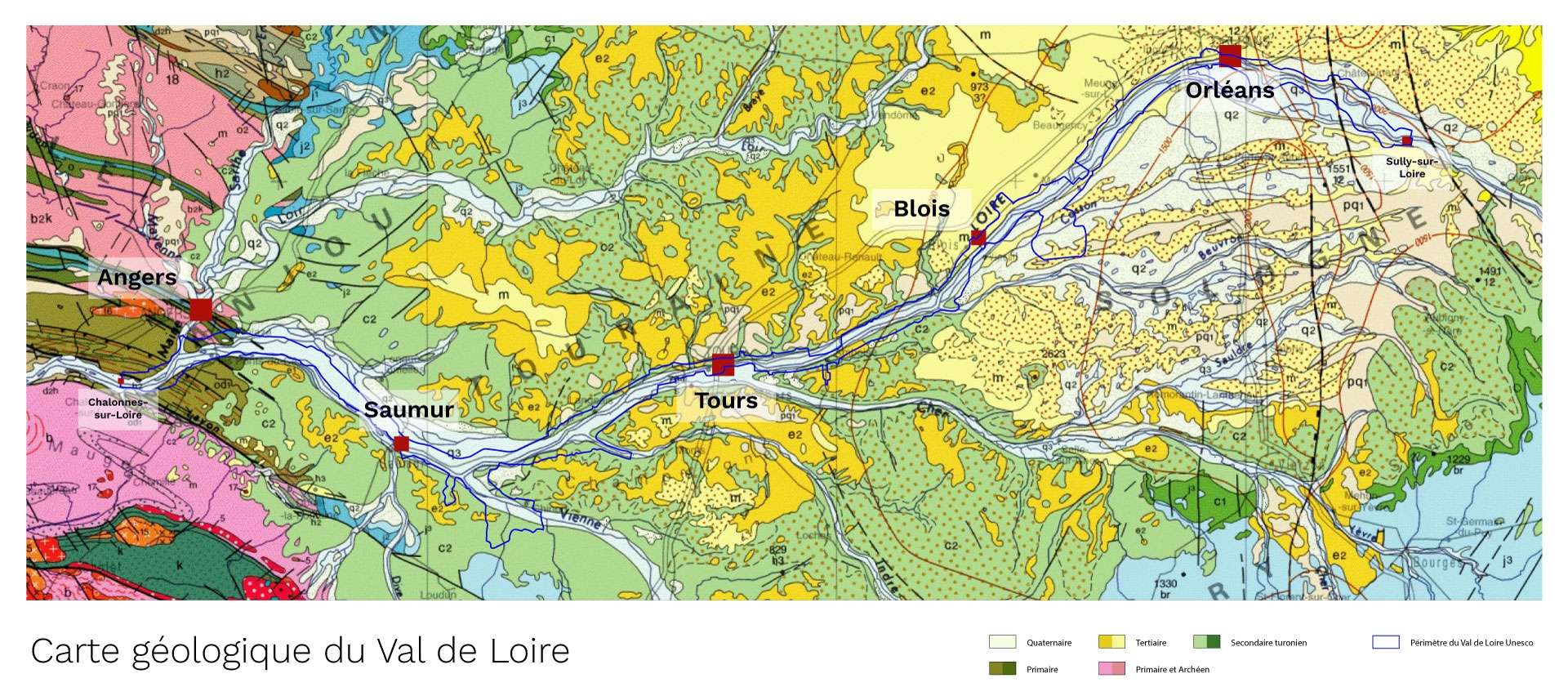
To understand the Loire Valley landscapes, we need a bit of geology. From its sources to its estuary, the Loire carries sediment from the Massif Central, the banks of the Orléans region and the Armorican Massif. The river deposited these as the terrain and currents changed.
In the upper Loire, the river passes between the volcanic rock of the Ardèche plateau before reaching the granite gorges. On leaving the Massif Central, its flow slows as it heads north-west, through the sedimentary strata. This is when the river style changes, henceforth characterised by meanders and multiple channels typical of a braided river.
After meandering through the alluvial deposits of Sologne, the river flows between carbonate rocks from different periods, starting with Beauce limestone harking from a lake formation which dyked up the right bank. Records of its extraction, in the form of rubblestone or aggregate, date back to antiquity and continue until the 19th century in Orléans. This building material is a common sight as far as Blois. Then, between Blois and Amboise, white chalk is the defining feature of the main landscapes such as at Chaumont-sur-Loire. Further west, the two types of tuffeau stone have been used in buildings: white for monuments and yellow for the levees.
On the left bank, the towns of Candes, Montsoreau and Saumur rose up on the Turonian tuffeau. On the right bank, before joining Angers and the Armorican Massif, then the estuary, the River Authion runs alongside the Loire. The alluvial plain evolves into “polders”, fertile land hemmed in by the levee.
In the Middle Loire region, the confluence zones are characterised by vast expanses of meanders: the valley widens and the river flows for several miles parallel to its tributary before they join up. Islands appear and disappear as the water levels rise and fall. Sometimes they stay put, allowing abundant vegetation to take root. Alluvium can form insubmersible dunes (remains of old alluvial terraces), that are difficult to make out, on which farms and hamlets have sometimes developed.
Beyond Les Ponts-de-Cé, the river follows a valley hollowed out through the Armorican Massif as far as the estuary. Schist, mica schist, sandstone and even Layon coal run alongside the Loire, sediments from which are deposited on the beaches of the Atlantic Coast.